Alumni

Lena Libon
Bio
Lena Libon attends Michaeli-Gymnasium high school in Munich, Germany. Lena is interested in computer science and mathematics, especially artificial intelligence and robotics. She won several prizes in computer science, mathematics and physics competitions. She likes coding with Java and Python. She also enjoys playing basketball, reading and listening to music.
Project: Predicting Mountains’ Locations
Goal
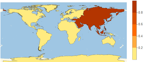
My program classifies the country of a given mountain’s elevation data. The data is sent into a neural network, which was trained on the elevation data of the five highest mountains per country in Europe. Then, the program returns a map displaying the location of the mountain. Another neural network, trained on the relief plot of the 10 highest mountains per continent, recognizes the continent of which the elevation data belongs to and then plots the probabilities of that mountain belonging to the continent using a map with different colors referring to different probabilities. The third approach is to recognize a mountain by its profile, which you can easily create using the ListPlot3D function.
Summary of Results
1) I started by making a 3D plot of the 10 highest mountains in the world and fitting pictures from different viewpoints of the mountains into a neural network. Thereby, the program is able to recognize them by their profile. In order to train a useful neural network, a great amount of data is required. This method did not turn out to be useful because the performance of my computer could not produce the required number of graphics in a reasonable amount of time. 2) Carrying on, I trained a network on the 10 highest mountains on each continent, supported by more data creating using GeoRange and varying the center of the plot. After the program has been trained with most of these pictures, the result is relatively good. By providing elevation data to the neural net, it returns the respective probabilities for the continents, which are then illustrated on a map. 3) As a final result, I created a neural net trained on slightly varied elevation data, which classifies the country in Europe to which the mountain belongs.
Future Work
1) Create more data: predictions of countries on other continents and more detailed descriptions of the position, such as the city. 2) Improve the neural net: creating its own network and using transfer learning. 3) Add extra features: giving the user extra information on the mountain (e.g. height, the degree of difficulty when climbing, etc.).