Alumni

Khang Minh Nguyen
Bio
Minh Khang is a rising senior at High School for the Gifted in Vietnam and is pursuing a specialized track in informatics. Currently, he is learning basic statistics and linear algebra independently at home in his free time. Besides that, he usually participates in various soccer tournaments in his neighborhood. Like other kids all over the world, he is a big fan of the Marvel Universe; he especially fancies the blend between science and art within the movies. In the future, Khang hopes to further develop himself in the interacting area between computer science and mathematics.
Project: Use Machine Learning to Predict if Topography Is Above Water or Underwater
Goal
Topography is the arrangement of the natural and artificial physical features of an arbitrary area, and the goal of the project is trying to predict if a given topography is above water or underwater (perhaps in an ocean). Firstly, I have to scrape a bunch of data of various topographies for each different location on Earth that may be on land or deep in the sea. I plan to use machine learning to do the classification and, on the way, explore other algorithms and features that could improve accuracy.
Summary of Results
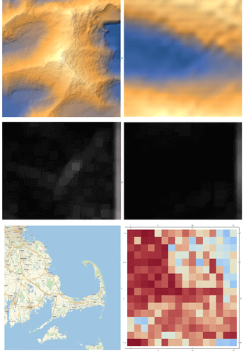
To summarize, in the first step, I collected topographies from both on land and underwater. Then in the second and most complicated step, I tried to use a discrete Fourier transform (DFT) for a topography image into the matrix, but the problem was that all of the Fourier images were very similar. Then I tried applying a high-frequency filter on the images. High-frequency filtered outputs were easy to distinguish since surfaces above water are generally rough when compared to surfaces underwater. After the image processing step, I created two training sets; one is an on-land training set and another one is an underwater features training set. Hence, I went straight to using the Classify function and the final function to return probabilities of "Land" and "Sea". Finally, for an extra challenge and a nice application for my project, I generated a temperature map for a part of Boston and tried to compare it to the actual map, and the generated heat map is similar to the real map.
Future Work
As we can see, from an arbitrary relief plot of a location, it is possible to turn the relief one into the thermometer surface where blue represents "Sea" and red represents "Land" by using the probabilities that the classifier returned. The next thing that needs to be done is to think of other crucial parameters that can be used, like water bodies around buildings etc., to increase the accuracy. After increasing the accuracy, an interesting thing to do would be to analyze the topography of other celestial bodies (like Mars) and then predict regions where liquids flowed on the surface.