Alumni

Arian Patel
Bio
Arian Patel is a rising senior at the Loudoun Academy of Science in Loudoun county, Virginia. Arian loves science and math; he had fun in his BC calculus class (including working with Mathematica), is learning AP physics C mechanics on his own, and is researching how to make aquatic plant duckweed the world's most advanced and efficient fertilizer. Arian speaks German fluently, and has completed internships at Porsche and SAP in Germany. When he's not almost losing his fingers in the lab, he enjoys being a part of his Tae Kwon Do championship team as a fourth-degree black belt. Arian also loves rowing on his high school’s varsity crew team, being outdoors, and cooking.
Project: Visualizing the effect of sea level rise on a topographic map
Goal
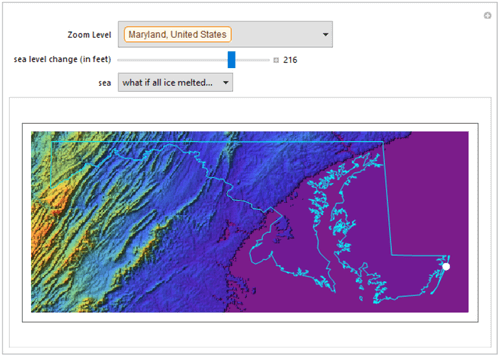
This project builds upon a previous Demonstration, creating a function that demonstrates sea level rise in a more user-friendly manner. With this, the user can view any area or region in the world and manipulate the sea level to see how various locations could potentially be affected. Political boundaries have also been included to better visualize the loss of land. In addition, the user can input their address, and a map with multiple zoom levels will be displayed around their address. National Geographic predicts that if all ice on earth melted, the sea level would rise by 216 feet, so an option to view any area at 216 feet of sea level rise has been implemented.
Summary of Results
These plots and GIFs demonstrate that even a small change in sea level can wipe out a large amount of land in states such as Florida and Maryland. Additionally, the predicted maximum rise of 216 feet could have strong effects in various regions of the world and would wipe out many cities and regions without proper preparation for sea level rise.
Future Work
In order to make this work more accessible, the functions could be put on a website to allow for anyone to explore sea level rise. Another possible feature would be to return the land lost for any given area to give more perspective on how a small global change could potentially have a large impact. Finally, the function could consider land under the sea level, such as the Netherlands, to more accurately portray how they are filled.